A tailored solution for road construction.
Smart and customizable positioning for road construction and civil engineering applications.
Leica iCON site
A tailored solution for road construction.
Smart and customizable positioning for road construction and civil engineering applications.
iCON site construction software
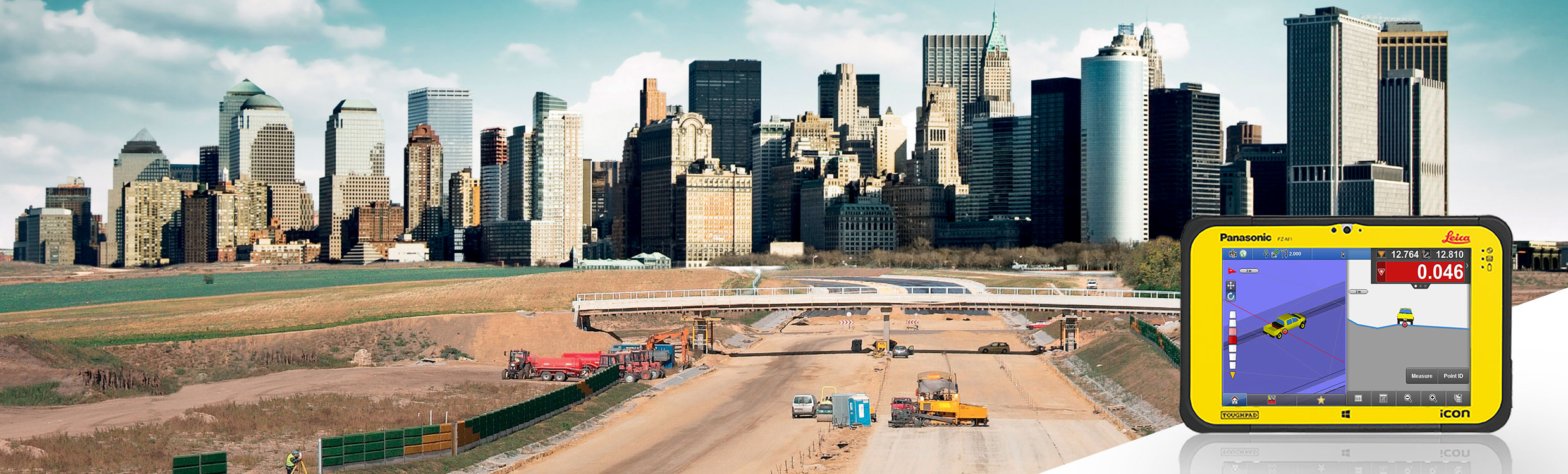
The Leica iCON site software offers smart and customizable positioning solutions for road construction and civil engineering applications. Increase speed, performance, and accuracy when performing all positioning tasks with a single, very easy-to-use software solution.
Smart Workflow
In addition to enhancing performance with smart software applications, the workflow and innovative software design, the iCON site intuitive user interface offers maximum precision and flexibility for your construction projects.
- Simple interface designed for construction professionals
- Seamless integration with all iCONstruct sensors and controllers
- Exceptional application functionality tailored to the positioning needs in road construction
- Seamless data integration into the range and workflows of iCONtrol machine control
- Complete customizable solution to increase productivity by focusing on tasks relevant to the job
Simple software design
The Leica iCON site software offers a whole new experience at work. Its innovative and simple software design, smart workflows, and simple user interface make working a pleasure and increase productivity on site.
Designed for construction professionals such as site managers, supervisors, levelers, machine operators, etc., who need to efficiently carry out measurement tasks on site
- Measurement tasks are simple and performed independently and immediately without interruption
- Eliminate uncertainties from your project for faster and more accurate billing
- Increase machine uptime by keeping them updated and productive
- Intuitive interface for users of any experience level
- Reduction to the main functionality to achieve concise work dynamics and results
- Faster familiarization with the product, starting with one or two applications and growing with your experience
- Warning system through signals for each staking point
- Connection with Leica Geosystems precise positioning sensors
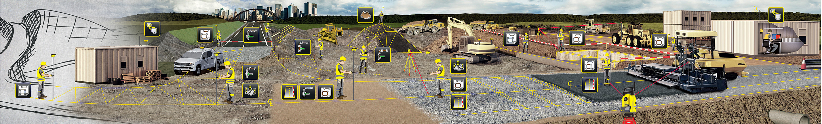
Support for machine control and Leica iCON telematics
The wide range of Leica iCON products is designed to efficiently connect the various tasks on the construction site. Integration and connectivity from the office, machine, and field increase site productivity and ensure high uptime on site.
iCON site is the perfect addition when operating machinery, whether used in 2D or 3D. With 2D, it allows the machine to obtain the absolute position on site. With 3D, the same data is used in the field and office, increasing the quality and efficiency of the data. As-built checks with iCON site are compatible with all field workflows.
The iCON site software is also compatible with Leica iCON telematics, which allows you to increase the efficiency of your tasks on site (with iCON site) and machine control operations, as well as manage your fleet remotely.
Applications
Combine the Leica iCON site software with the Leica iCON robot 60 robotic total station for the following applications:
- Positioning tasks with maximum precision
- Staking points or lines for roads and intersections
- As-built drawings of sewers, pipelines, finished road surfaces
- 3D control of graders and pavers
- Volume calculations
Combine the Leica iCON site software with the Leica iCON gps 60 SmartAntenna for the following applications:
- Positioning tasks with maximum flexibility
- Setting up the base station on site
- Staking out design objects on roads, such as lines, points, reference lines, road designs
- Cut and fill measurements
- Volume calculations
- Approximate and precise slope verification
- Simple slope machine control
You might also like
Product image thumbs bottom

Product image thumbs left

Product image thumbs right

Product image no thumbs

Product image no thumbs center

Product image no thumbs fullwidth

Product image gallery

Duplicate of Product image thumbs bottom
detail2833693304
![detail2833693304]()
Duplicate of detail2833693304
![Duplicate of detail2833693304]()
productos nuevo prueba
![productos nuevo prueba]()