Ultimate software for preparing construction data.
Effective on-site data control for surface verification, surveying, staking, or the use of machine control systems. The effectiveness of these tasks will depend on the guaranteed integrity of the applied design data. Leica iCON office data preparation software offers a comprehensive set of tools for preparing, editing, and reporting data to meet all the needs of contractors.
Leica iCON office
Ultimate software for preparing construction data.
Effective on-site data control for surface verification, surveying, staking, or the use of machine control systems. The effectiveness of these tasks will depend on the guaranteed integrity of the applied design data. Leica iCON office data preparation software offers a comprehensive set of tools for preparing, editing, and reporting data to meet all the needs of contractors.
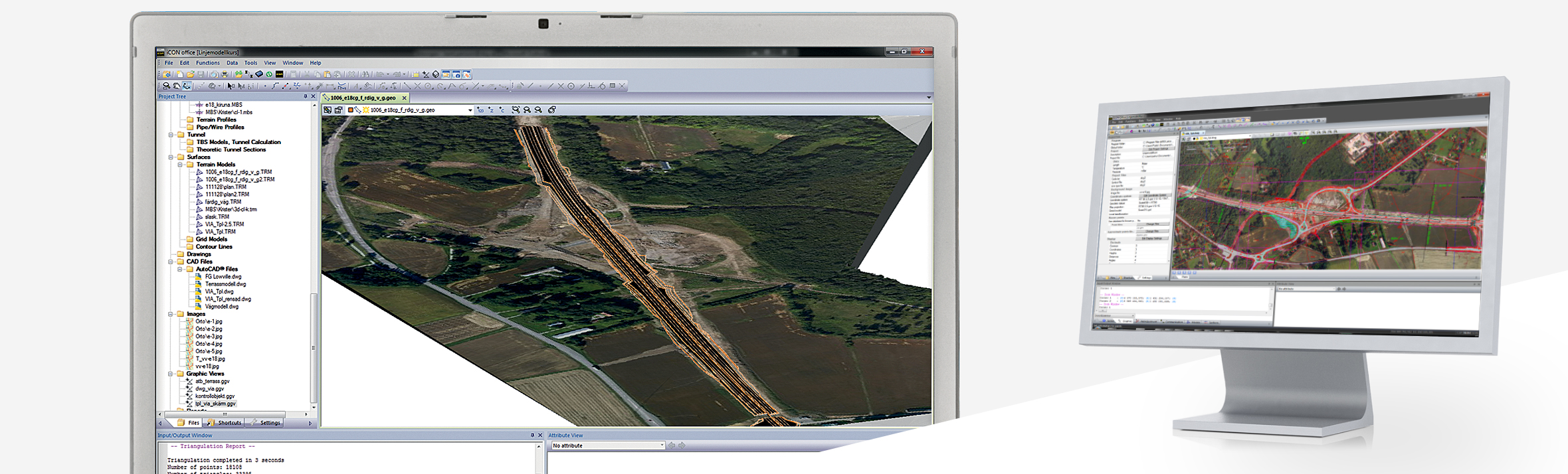
iCON office data preparation software
The Leica iCON office data preparation software offers a comprehensive set of tools for preparing, editing, and reporting data that meets all the needs of contractors.
Compatibility with the formats you use
From design to field, the philosophy of Leica iCON office is to use the shortest path possible. By working closely with local and international design software providers, Leica Geosystems has developed an application that can import and export data formats that have become industry standards, as well as numerous data formats used only in certain regions. Among others, these formats include:
- AutoCAD DWG
- AutoCAD DXF
- LandXML
- MX / Moss
- REB
- Ispol
Advantages of Leica iCON office
With Leica iCON office you will only use one application that is compatible with many data formats from a wide variety of independent software packages. A single application brings all data sources together into a project and provides full control when converting design data into construction information.
- Work with a wide range of different design models: In Leica iCON office, various design entities can be used, from simple road alignments to more complex reference lines, cross-section or layer models, as well as digital terrain models and background maps.
- Compatible with various machine control systems: Send design data to all sensors and machines from a single package. The software is compatible with a wide range of machine control systems and measurement sensors, both from Leica Geosystems and other manufacturers.
- Calculate cost estimates of executed work using volume analysis: The optional terrain module for Leica iCON office allows surface-to-surface or surface-to-elevation volume calculations to determine costs. This module provides complete control over the surface models used for the calculation, including boundaries and break lines. The module can also be used to create terrain profiles and sections.
- Simple and quick quality reports: Leica iCON office offers several standard reports for quality control. For example, a statistical report for checking and tolerance of deviations from the designed surface can be created at the touch of a button.
- View your data in Google Earth™: With Leica iCON office it is easy to view the project data in Google Earth™, just press a button and you can see the data directly in Google Earth™.
- Save time and money: The Leica iCON office data preparation package features a user-friendly interface that will have you up and running in no time. Take advantage of the self-training package supplied with the software or benefit from the free technical support for one year included with the license. Additionally, Leica iCON office works in the usual way for you, using the integrated AutoCAD® engine to open and edit native AutoCAD® drawings.
Invest in what you really need
Leica iCON office has a basic version to which functionalities can be easily added. It offers several additional modules to meet your daily needs:
- Road design lines
- Terrain models
- Volume calculation by sections
- Tunnels
- Point cloud
- Network adjustment
You might also like
Product image thumbs bottom

Product image thumbs left

Product image thumbs right

Product image no thumbs

Product image no thumbs center

Product image no thumbs fullwidth

Product image gallery

Duplicate of Product image thumbs bottom
detail2833693304
![detail2833693304]()
Duplicate of detail2833693304
![Duplicate of detail2833693304]()
productos nuevo prueba
![productos nuevo prueba]()