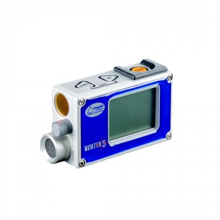
Haglöf Vertex Laser Geo Hypsometer.
High-precision laser rangefinder with integrated GPS and compass.
Haglöf Vertex Laser Geo Hypsometer.
High-precision laser rangefinder with integrated GPS and compass.
New models with EXTREME functionality - programmable with built-in GPS and compass.
Main features of Haglof Vertex Laser Geo:
|
|
 |
 |
 |
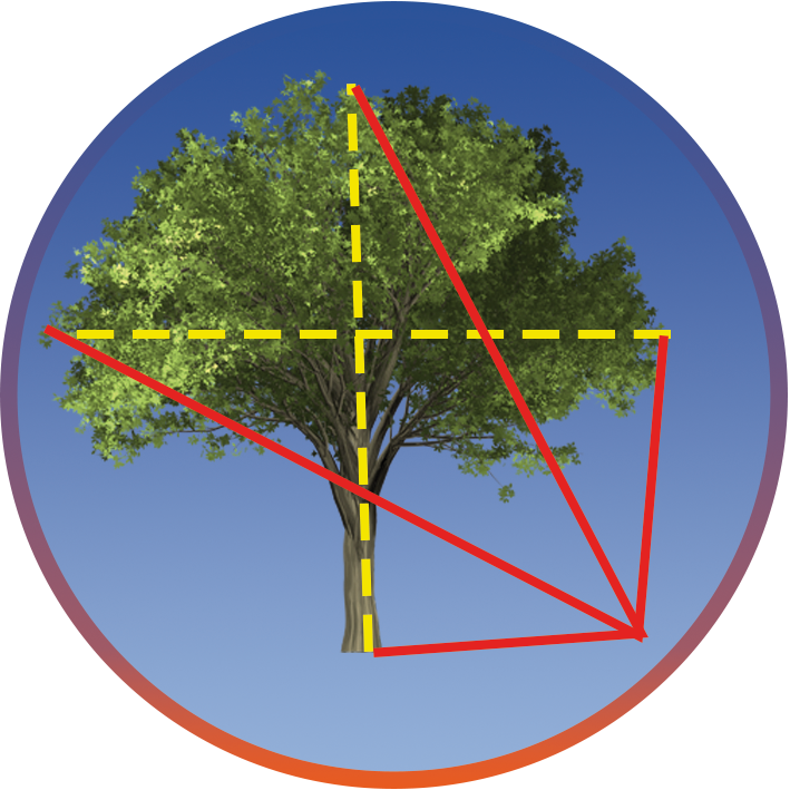
Height and CanopyHeights3-point, 2-point, or 1-point measurement or direct measurement: choose the preferred method to work in the easy-to-follow menu system. The Vector 3D feature allows you to measure remote targets, such as the width of the canopy or overhang. |
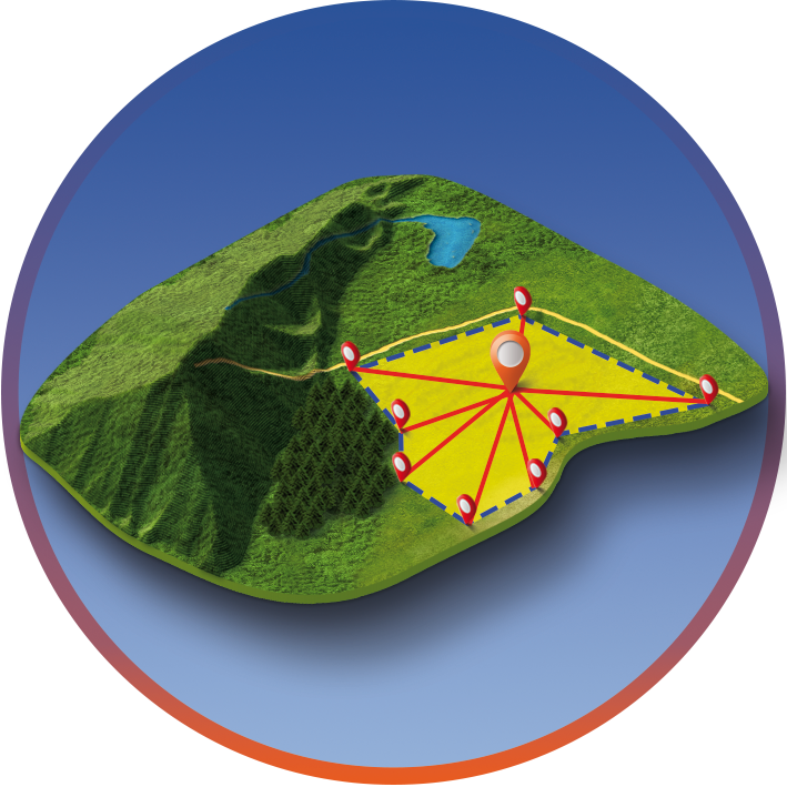
3D Map AreaArea MeasurementUse the built-in GPS to walk and record an area. Or stand at the center of the area and use the built-in GPS, compass, and laser to measure the points at the edge of the area. View results directly in Google Earth or other similar geographic applications. |
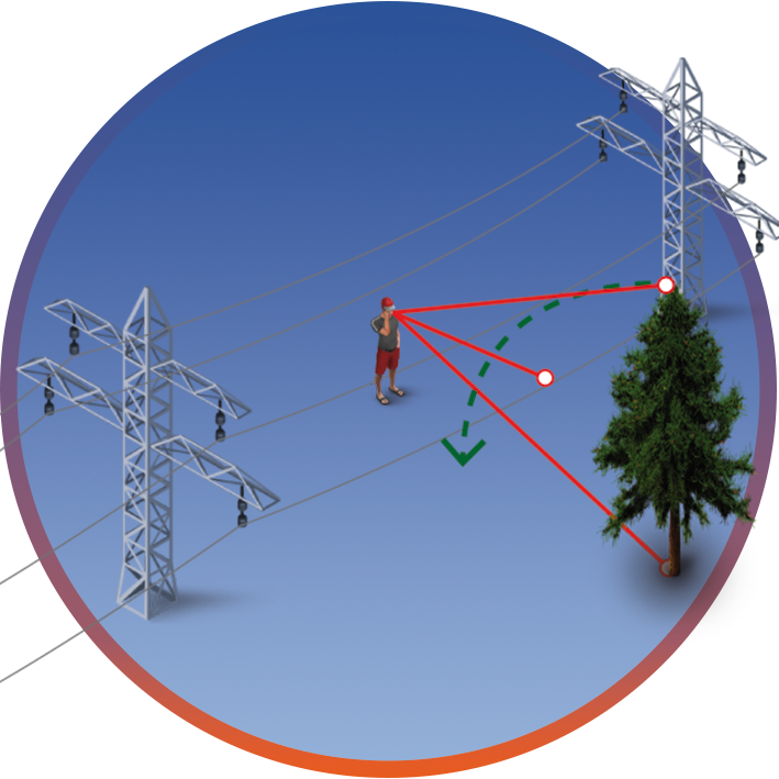
Line ClearanceHazard TreesLine Clear Function.
|
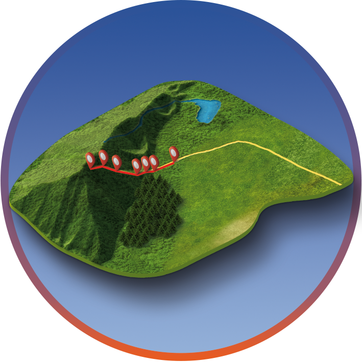
3D Map TrailsMeasure and plan access routes in forests. Measure where a cable car should pass for the logging or ski stations. Positions in the poles, separated in height for the entire distance. Results directly in Google Earth or other similar geographic applications. |
The Vertex Laser Geo, with unique features, will allow you to measure, map, process, and store forest and field data in a way you never thought possible. Long-range measurement with high-precision laser and built-in tilt sensors and compass for precise 3D measurements. Results are presented on an integrated front display and an external graphic display.
The integrated GPS receiver and a 5-position numerical identification attribute allow you to tag important data with coordinates with just the press of a key.
The data is stored in an integrated SSD unit and is immediately available for post-processing by connecting a standard USB 2.0 interface to any PC or Apple computer.
No installation routines, conversion software, or special drivers are needed. Your field data can be opened directly in your favorite GIS application or spreadsheet.
Complex operations, such as area measurement, 3D mapping of targets, and trail mapping, have built-in functions that are also available to you without the need for external tools. The Vector 3D function allows you to measure horizontal targets like canopy width.
3-point, 2-point, or 1-point measurement or direct measurement: choose the preferred method to work in the easy-to-follow menu system. A no-magnification sight helps you identify individual targets such as treetops and power lines.
With the Vertex Laser Geo, you can choose to use ultrasound to measure distances in dense vegetation with a lot of undergrowth.
When using the ultrasound and the central plot rod with the 360˚ adapter at the center of a sample plot, you can easily measure the distance and check if the plot trees are within the correct radius to be measured.
When using a prism or similar, there is the BAF "Basal Area Function" to control the minimum (DBH) that the tree must have to be counted in the sampling points.
BAF factors: 0.5, 1 to 9 (m2/ha) or 5, 10, 15..to 50 (ft2/acre)
The Vertex Laser Geo can be used in dense vegetation and undergrowth when using ultrasound.
Use the built-in GPS to walk and record an area. Or stand at the center of the area and use the built-in GPS, compass, and laser to measure the points at the boundary of the area.
Results directly in Google Earth or other similar geographic applications.
The 3D Vector function allows you to measure remote targets, such as horizontal distances and angles between two distant points on the ground, like the width of tree canopies or the width of a river.
Haglöf Sweden presents laser rangefinder models with exceptional capabilities for your most precise and efficient field measurement operations.
You might also like