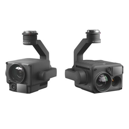
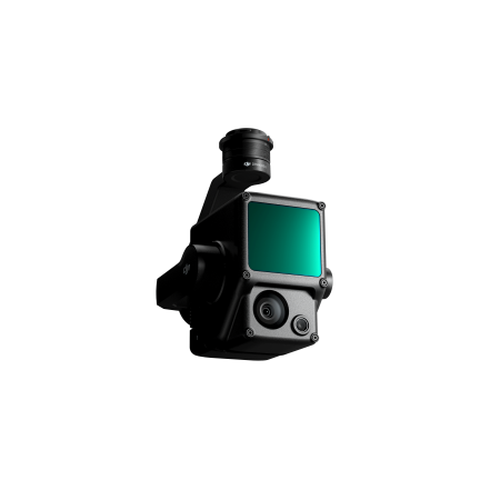
Discover the revolutionary Zenmuse L2: Frame LiDAR, high-precision IMU, and 4/3 RGB camera.
Enhance your DJI flight platform with precise and efficient geospatial data. In combination with DJI Terra, obtain a comprehensive solution ready for 3D data collection and high-precision post-processing.
Discover the revolutionary Zenmuse L2: Frame LiDAR, high-precision IMU, and 4/3 RGB camera.
Enhance your DJI flight platform with precise and efficient geospatial data. In combination with DJI Terra, obtain a comprehensive solution ready for 3D data collection and high-precision post-processing.
The integrated LiDAR solution of the Zenmuse L2 allows accurate scanning of complex targets, with greater range and speed. During operations, users can preview, replay, and process point cloud models on-site. DJI Terra generates quality reports, offering a one-step comprehensive solution to improve efficiency. Achieve high-precision results in point clouds with simplified post-processing.
The Zenmuse L2 redefines precision with an exceptional combination of GNSS and its own IMU, achieving vertical accuracy of 4 cm and horizontal accuracy of 5 cm. This level of detail ensures high-quality results in data collection.
Efficiency reaches new limits, as the L2 is ready to operate upon powering on, collecting geospatial and RGB data over an impressive area of 2.5 km² in a single flight. This not only saves time but also enhances overall operational effectiveness.
With its intuitive operation and compatibility with the Matrice 350 RTK and DJI Terra, the Zenmuse L2 offers an all-in-one, easy-to-use solution. This expands access to this advanced technology, allowing more operators to take advantage of its capabilities without compromising ease of use.
Experience a 30% increase in detection range with the Zenmuse L2. With the ability to detect objects from 250 m with 10% reflectivity up to 450 m with 50% reflectivity, and an operational altitude of up to 120 meters, it significantly improves operational safety and efficiency.
Smaller laser points, measuring 4x12 cm at 100 m, generate denser point clouds. This not only allows for the detection of smaller objects with greater detail but also facilitates penetration through dense vegetation and the creation of more accurate digital elevation models.
The Zenmuse L2 stands out with the ability to support 5 returns, capturing more ground points even in densely vegetated areas. With an effective point cloud rate of 240,000 points per second in both single and multiple return modes, the L2 provides an exceptional amount of point cloud data in a limited time. With two scanning modes, repetitive and non-repetitive, it adapts to various tasks, from high-precision mapping to power line inspection and forestry surveying.
The Zenmuse L2 incorporates a high-precision IMU system developed in-house, enhancing data accuracy. In combination with the drone's RTK positioning system, during post-processing, the L2 accesses precise absolute position, speed, and altitude information, improving overall data quality.
With real-time yaw accuracy of 0.2° and 0.05° in post-processing, as well as real-time pitch/roll accuracy of 0.05° and 0.025° in post-processing, the L2 ensures extremely precise measurements. Additionally, its IMU system requires no warm-up, providing optimized performance from startup.
The Zenmuse L2 is equipped with a high-quality RGB mapping camera, featuring a 4/3 CMOS sensor and a mechanical shutter. The increase in pixel size to 3.3 μm and an effective capacity of 20 MP result in a remarkable improvement in the overall imaging system, providing sharper details in point clouds with rich, true colors.
Various Flight Route Types |
Live Point Cloud View |
| Supports Trajectory, Area, and Linear routes for mapping tasks in a wide variety of environments. | During operation, DJI Pilot 2 provides three display modes: RGB, point cloud, and parallel point cloud/RGB, intuitively presenting operational results. |
You might also like