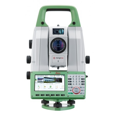
The latest all-terrain, combining the functionality of the total station with 3D laser scanning, GNSS connectivity, and digital imaging.
Smart multi-sensor station with scanner for precision tasks. The Leica MS60 offers a measurement accuracy of up to 0.5 mm at distances of up to 200 meters, making it one of the most accurate tools on the market. Additionally, its high-speed laser scanning system allows for capturing 3D point clouds with exceptional image quality, facilitating the creation of detailed and accurate models of any terrain or structure.
The Leica MS60 also features a wide range of integrated software tools that simplify the workflow and enable the execution of complex tasks with great ease. These include point cloud registration tools, model fitting, quality control, and much more.
Consulta nuestras condiciones de financiación.
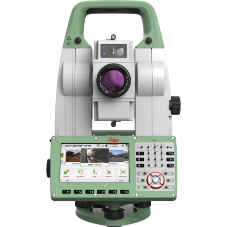
The new version of the Leica Nova MS60, the world's first MultiStation, allows you to perform all surveying tasks with a single instrument. It takes sensor fusion to the next level by combining:

The MS60 comes with Leica Captivate, integrated software with easy-to-use applications covering all your surveying tasks. To make your work even more productive, on the MS60 you can benefit from Dynamic Lock, as well as the new and revolutionary AutoHeight parking assistant feature, which helps you park even faster and more accurately at the touch of a button.
Main Uses for Leica Nova MS60:
To meet the demands of this rapidly changing world, Leica has developed the world's first MultiStation that combines all available measurement technologies in one superior instrument. Now, we've also made the instrument even smarter. The Leica Nova MS60 MultiStation is the world's first intelligent MultiStation that automatically and constantly adapts to any environment, no matter the challenge.
Scanning with the Leica Nova MS60 has been simplified through instant creation of point clouds and 3D models in one visualization. Visualizations are clearer and easier to view on our new 5" displays.
The unique capabilities of the Leica Nova MultiStation truly deliver a new experience in measurement technology.
High-precision angle and distance measurements, durable design, and easy-to-use applications are key elements of modern total stations, fully incorporated in the MS60. With enhanced automation features using ATRplus, the MultiStation increases your efficiency, even in challenging environmental conditions.
Scan up to 30,000 points per second (Hz): quickly perform your scans and obtain dense scan grids. The MS60 features optimized scanning paths that now include zenith scans, allowing you to significantly reduce total scan time.
GNSS is fully integrated into the workflow and data structure, allowing for direct georeferencing. Additionally, SmartStation and SmartPole configurations increase your flexibility in the field.
Enhanced digital imaging technology, including an overview and a coaxial camera with 30x magnification, allows for assisted surveys with precise images both in the instrument and remotely, while including extended image documentation.
You can customize your MultiStation to meet your needs with:
To enhance your experience working with your MS60, take advantage of Leica Geosystems' Customer Care Packages. Our global network of experienced professionals is just a click away to assist you with any questions. Plus, you can control your spending with a customized Customer Care Package (CCP) solution, giving you peace of mind knowing you're covered anywhere, anytime.
You might also like