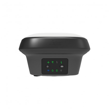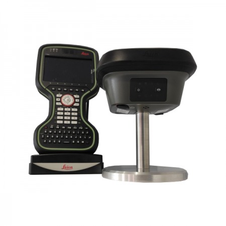
Imagine the power of GNSS positioning with images. The Leica GS18 I is a GNSS (Global Navigation Satellite System) device with built-in imaging from Leica Geosystems. It's a high-precision, high-performance surveying instrument that provides fast and accurate measurements of location, altitude, and orientation.
The integrated imaging allows users to take pictures of measurement points and associate them with GNSS data, improving the efficiency and accuracy of topographic surveys. Additionally, its robust and rugged design makes it ideal for working in demanding outdoor conditions.
Consulta nuestras condiciones de financiación. / Consult our financing conditions.
Introducing the Leica GS18 I, a versatile, high-precision RTK GNSS mobile with Imaging Positioning. Designed for surveying professionals, it allows for easy and precise measurement of points that were previously impossible to measure with a mobile GNSS unit. Now you can quickly capture the site with images and measure points from them, whether in the field or later in the office.
The fusion of GNSS, IMU, and camera sensors working together to create Image Positioning technology results in such a powerful RTK GNSS mobile that it allows you to measure what you see. The GS18 I has all the functions of the Leica GS18 T: for example, in addition to image positioning, users can measure points with the pole tilted or leveled.
The GS18 I is an accurate and easy-to-use RTK GNSS mobile. It employs innovative image positioning technology based on the seamless integration of GNSS, IMU, and camera. It allows you to measure points with topographic accuracy from images, whether in the field or in the office. You can also create point clouds from captured images using Leica Infinity and further expand the possibilities.
Designed to measure a large number of points with total efficiency. The GS18 I allows you to capture images and measure hundreds of points in minutes without the need to physically reach each point. On-site time is reduced, and revisits are minimized; once a capture of that site is made, you can measure all the details whenever you want.
The power of the image has changed the game. By being able to measure what you see, it is now possible to reach places that could not be reached before without the need for tools or overcoming and circumventing obstacles. This offers flexibility in the field, frees up teams and operators, maximizes productivity, and increases profits to the fullest.
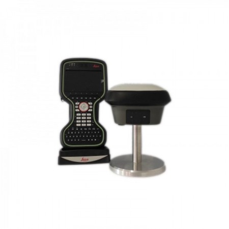
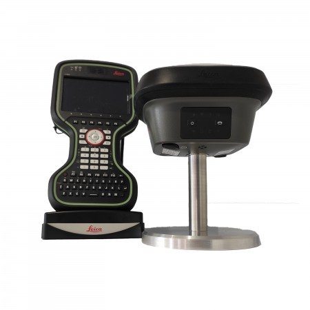
Capture and measure in the field with the GS18 I RTK mobile using Leica Captivate software. The ease of use allows you to capture and manage data clearly and accurately. Leica Captivate field software is the perfect companion for the GS18 I. With easy-to-use apps, you can view and use all measured and design data, giving you a clear understanding of the data in 2D and 3D views. Captivate spans industries and applications with little more than a simple touch, whether you're working with GNSS, total stations, or both.
Use Captivate to capture and process data in the field, or use Infinity to measure points when you're back in the office and can work comfortably on a larger screen without the hassle of weather conditions or traffic. Infinity surveying software is designed to manage, analyze, and control the quality of all field surveying data from GNSS sensors, total stations, digital levels, and UAV images.
Based on the fusion of IMU and GNSS sensors, the tilt compensation of the GS18 I is immune to magnetic disturbances and can be put into operation immediately without calibration. With the GS18 I, surveyors have the flexibility to measure points with a leveled pole and continue to save the tilt values of each measurement. This way, you can be confident that what you've measured is correct.
Users with any GS18 model have the flexibility to record raw data on an SD card or internal memory.
Multi-frequency signal tracking comes standard with all Leica Geosystems GS receivers. And, combined with an excellent GNSS antenna and a position update frequency of 20 Hz, the GS18 I ensures highly reliable measurement quality.
Signal multipath effect reduction and interference reduction options in Captivate enhance GNSS signal tracking quality in complex environments, improving RTK availability and accuracy. Additionally, an interference filtering toolkit allows you to eliminate in-band and out-of-band distortions for even more robust GNSS signal tracking.
Through Active Customer Care (ACC), a global network of experienced professionals is just a click away to guide you through any challenge. Control your costs with a Customer Care Package (CCP), giving you the peace of mind of knowing you're covered anytime, anywhere.
You might also like